Marianas Trench Marine National Monument
New Film - Stories of the Islands Unit
New short documentary on human experiences from the Islands Unit of the Marianas Trench Marine National Monument, Stories of the Islands Unit.
The JIMAR Human Dimensions group and Urban Spider Design collaborated on a short documentary called Stories of the Islands Unit. The documentary showcases Commonwealth of the Northern Mariana Islands (CNMI) residents’ experiences from the islands and waters surrounding Uracas (Farallon de Pajaros), Maug, and Asuncion, the area now known as the Islands Unit of the of the Marianas Trench Marine National Monument. JIMAR Human Dimensions researcher, Dawn Kotowicz interviewed scientists, fishermen and former residents about living, fishing, exploring and studying this region to provide a unique and personal perspective on this infrequently visited area. This project was funded by NOAA Fisheries Pacific Islands Fisheries Science Center and NOAA Fisheries Pacific Islands Regional Office.
Thanks to Heidi Hirsch of the NOAA Marine National Monuments Program for this description of the film.
Posted March 20, 2015
Here is an update on the
Monument Management Plan (MMP) for the Marianas Trench Marine National Monument
from Laura Beauregard of the Hawaii & Pacific Islands National Wildlife Refuge Complex (NWRC):
Hafa Adai -
A multi-year, multi-agency planning process continues to develop a Monument Management Plan (MMP) for the Marianas Trench Marine National Monument. As stated in Presidential Proclamation 8335, the Secretaries of the Interior and Commerce are required to complete a MMP to guide the management of the monument’s resources. The U.S. Fish and Wildlife Service and the National Oceanic and Atmospheric Administration are working together in the development of the MMP, and in cooperation with the Secretary of Defense, the U.S. Coast Guard, and the Government of the Commonwealth of the Northern Marianas Islands. I am pleased to announce the availability of our latest planning update. Planning Update 3 provides a summary of the comments and questions we received during the public scoping meetings on Saipan, Rota, Tinian, and Guam last year, along with the initial agency responses.
To download, please visit:
http://www.fws.gov/marianastrenchmarinemonument/planning.html
Thank you,
Laura Beauregard
Hawaiian & Pacific Islands NWRC
300 Ala Moana Blvd, Rm 5-231
Honolulu, HI 96850
808-792-9558
Posted April 19, 2013
the marianas trench information site
Posted April, 2013
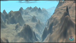
Mariana Trench Movie This is a downloadable 43 second animated flyover and flythrough of the Mariana Trench, ending at Challenger Deep, the deepest spot in all of the oceans. The download is available in several sizes. The 6- and 29 Mb versions don't take too long to download and are good visually.
Posted April 9, 2013
Brand new video produced by APASEEM: First Voyage to the Marianas Trench Marine National Monument
Posted Jan 5, 2013.
The nearby Marianas Trench contains the site of the deepest place on earth, Challenger Deep. A web site for the Mariana Trench Marine National Monument has been created by the US Fish and Wildlife Service (FWS). The Monument consists of 95,216 square miles (60,938,240 acres) of protected submerged lands and waters of the Mariana Archipelago.The FWS also makes available a two page brief (pdf) that gives a succint description of the monument, it's history and future along with some excellent photographs.
NOAA(National Oceanic and Atmospheric Administration) has information about the entire Marine National Monument Program, which includes the Mariana Trench Marine National Monument.
Q: Why do you see the name spelled both "Mariana" and "Marianas"? A: Both ways are acceptable spellings and the source's spelling is usually preserved on this site.
|
|
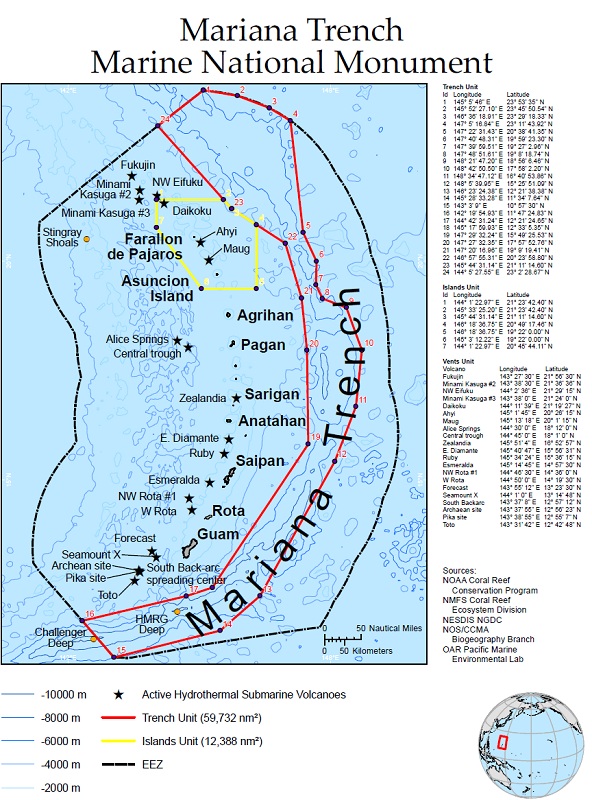
On January 6, 2009, President George W. Bush established the Marianas Trench Marine National Monument under the authority of the Antiquities Act of 1906. The monument incorporates approximately 95,216 square miles within three units in the Mariana Archipelago. The Mariana Trench Unit is almost 1,100 miles long and 44 miles wide and includes only the submerged lands. The Volcanic Unit consists of small circles (2.3 miles in diameter) around 21 undersea mud volcanoes and thermal vents along the Mariana Arc, again only the submerged lands. The Islands Unit includes only the waters and submerged lands of the three northernmost Mariana Islands, Farallon de Pajaros or Uracas, Maug, and Asuncion, below the mean low water line. Credit: U.S. Fish and Wildlife Service |
| Champagne vent at NW Eifuku volcano - Photo credit NOAA |
|

Topographical Map of the Mariana Trench and Surrounding Area from the website of Dr. Susan Clark Slaymaker, California State University, Sacramento, Geology Department
from NOAA National Geophysical Data Center (NGDC)
(as seen on the National Geographic channel, December 2006)